
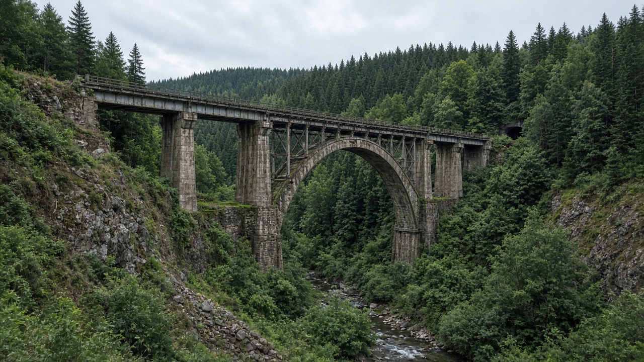
History: Toyohara–Maoka, Takaradai, and the ominous names
Devil and Witch Bridges are not movie sets — they are fragments of Japanese railway engineering from Karafuto Prefecture. The line between Toyohara (today’s Yuzhno-Sakhalinsk) and Maoka (Kholmsk) climbed steep terrain with the Takaradai spiral and a chain of tunnels; the bridges are commonly dated to the late 1920s (often 1928). After the railway’s decline, the rails vanished and the concrete arches remained as an industrial hiking corridor.
Folk names stuck because of height, pitch-black tunnels, and the feel of an empty forest corridor. Local legends set the mood; wear and tear set the real risk: drip, rockfall, slick concrete, and failing decking. Devil Bridge stands around 41 m and Witch Bridge around 50 m — approximate figures that still explain why the upper span intimidates more hikers.
Getting to the start: Nikolaychuk and kilometre 75
Most independent hikes begin at the 75 km platform / Nikolaychuk in Kholmsk District. Suburban trains from Yuzhno-Sakhalinsk (Orlan and current successors) change schedule and fare — check the carrier’s board on the day (this guide’s orientation date: 2026-09-28). If you are already on the west coast, drive or taxi from the Kholmsk side instead.
Confirm parking and the path to the first tunnel with recent trip reports — approaches grow over and informal lots get blocked. If you are touring the island by car, keep the Sakhalin road trip guide open and place the bridges in the west-coast block after Kholmsk, not between Aniva and a same-day flight.
Timed hike: Takaradai to Witch Bridge
The pattern is simple: climb the old grade → tunnels → Devil Bridge → higher to Witch Bridge → return the same way. Takaradai reads as stacked levels, not a signed park trail. In the tunnels a strong light is a requirement: without it you miss puddles, debris, and turns.
| Time | Segment |
|---|---|
| 0:00–0:40 | Start at Nikolaychuk / 75 km platform; climb toward the Takaradai spiral grades |
| 0:40–1:40 | First tunnels: strong headlamp, hood for drip, no solo “I’ll be quick” dashes |
| 1:40–2:40 | Devil Bridge (~41 m): photos from the gorge floor and gallery — stay off edges |
| 2:40–4:00 | Climb to Witch Bridge (~50 m): rotten sleepers, no railings — only in dry weather with a clear head |
| 4:00–6:00 | Return the same corridor; keep spare light and water for the way back |
Witch Bridge often means rotten sleepers and no real railings. If heights or wind bother you, turn around — you can still photograph the span from stable ground below. Bears use the area: hike noisily, leave no food, and avoid solo trips in shoulder season. Buy travel insurance that covers trekking and evacuation before you enter the first tunnel.
What to pack and when to go
The comfortable window is roughly June–October in dry weather. After rain, tunnels and bridge decks become especially slick. In winter this is a different outing entirely — ice and short days — so switch to the Sakhalin in winter guide for the cold-season island plan.
| Item | Why it matters |
|---|---|
| Lights | Headlamp plus a backup torch; tunnels are long and fully dark |
| Footwear | Hiking boots with grip; trainers skate on wet sleepers |
| Clothing | Layers and a rain shell; tunnels stay cold and damp in July |
| Bear protocol | Noise in a group, whistle; no food left behind; know the encounter drill |
| First aid & power | Basic kit plus a power bank; reception in the gorge is unreliable |
Self-guided hike or jeep tour
Going alone is cheaper and more flexible for photography, but you own navigation, fitness, and group safety. Jeep tours and local guides handle transfers, pacing, and often flag decking that has become unsafe. Compare excursions and jeep outings, and ask about group size, helmets/lights, and the rain plan.
| Option | Estimate | Notes |
|---|---|---|
| Suburban train (Orlan / current service) | low cost | Yuzhno-Sakhalinsk → 75 km / Nikolaychuk; recheck timetable (guide checked 2026-09-28) |
| Taxi / transfer from Kholmsk | negotiated | Handy if you are already based on the west coast with a car |
| Jeep excursion | from several thousand ₽ / person | Saves logistics; ask about group size and the operator’s insurance |
Overnight before or after the hike in Yuzhno-Sakhalinsk or Kholmsk — browse hotels. Reach the island with flights, and carry an eSIM for town logistics, knowing the gorge will still need an offline track.
Where to continue after the bridges
West-coast logic points to Nevelsk and, on a calm sea day, Moneron Island. If the whole trip is by car, return to the full Sakhalin road trip guide and treat the bridges as a hard physical day — not a quick stop between lunch and sunset.
Fit the bridges into days without a rush
Set your dates and pace — AlpacaBag will reserve daylight and a weather buffer for the Takaradai hike.
FAQ
What is the difference between Devil Bridge and Witch Bridge?
Both are concrete-and-steel railway bridges from the Karafuto era on the Toyohara–Maoka line. Devil Bridge is lower (~41 m) and usually comes first on the classic hike. Witch Bridge is higher (~50 m), with more damaged decking and no proper railings — that is where height fear and rotten sleepers stop many visitors.
How do you reach the trailhead?
Most independent hikes start at the 75 km platform / Nikolaychuk. Take a suburban train from Yuzhno-Sakhalinsk or drive/taxi from the Kholmsk side if you are already on the west coast. Confirm the current access point with recent local advice — parking and pathheads shift.
How long does the hike take?
Plan about 4–6 hours round trip depending on pace, photo stops, and trail condition. Start early: tunnels and the gorge lose usable light faster than the city clock suggests.
Is it safe to go without a guide?
This is not a maintained park path: wet tunnels, rockfall, rotten bridge timber, and bears in the area. Go as a group with strong lights and a sober height check at Witch Bridge. If you want transport and local judgment on unsafe decking, choose a jeep outing.
When is the best season?
Roughly June to October in dry weather. Ice, short days, and winter hazards turn the route into a specialised outing. Do not mix this summer hike with a general winter Sakhalin itinerary.